So, onwards into the land of surveying the land. Following the Design Process of SADIM (Survey, Analysis, Design, Implement, Maintain) I proceeded to make further observations of the site and get stuck into drawing maps.

This lengthy process also started to inform my thinking about what else the survey ought to include.

Scale Basemap #1 – shows the buildings
I’d already done a basemap of the field, but looking at it again, I realised I didn’t really have enough room to plot out the design of the orchard with the scale I’d used (I was on A4 here as well), so I set about making a x2 scale basemap from the original on which I could then do overlay maps. What you see next is that scaled up version with the sun map overlay that I did.

Overlay Map #1 – sun mapping form observation and a bit of guess work. Shown overlaid onto Basemap #2
It does actually go over perfectly! but scanning has taken it’s toll…
I then went through a series of overlay maps but using a different method, which was to use GoogleMaps as the Basemap, and then take a snapshot of that image and use a little browser extension that allowed for a little overlay mapping with basic drawing tools. You can see these in the Gallery below. I tried using the Keyline Scale of Permanence as a basis for my overlay maps:
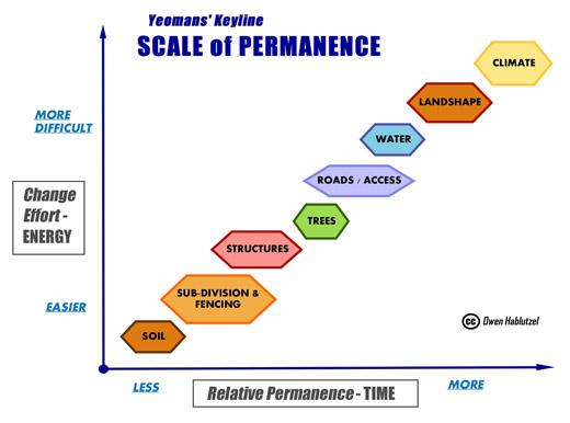
I tried to do a different Overlay map for each level, so:
- Climate (covered by sun maps and the weather research I did on the Met Office website)
- Land Shape (sort of drew a blank here – observed the shape of the field but I did not have the resource or time to walk an A-Frame across two acres of field to get the Countour Map done… more of this later – did manage to use a great website Sketchmap.co.uk to get the Height above sea level)
- Water (again, no particular water supply, sources or specific water storage on site currently aside form the rain)
- Roads (there is no road access – the field is totally land locked)
- Trees (some around the periphery, but that’s where I’d like to introduce more!)
- Buildings (some useful observations here)
- Subdivision (again some useful observations around the current boundaries and potential zoning of the field plus some more use of Sketchmap.co.uk for interesting geographic and other boundaries)
- Soil (no base map for this one – but I left part of my soil analysis to an expert – more later!)
The interesting thing about ‘Survey’ as part of the process, is that it’s quite hard for a mere mortal to ‘just observe’ without going into analysis, intellectualisation and problem solving or design. We have a tendency to want to run ahead.
Now, I said there was going to be some Kung Fu smattered around this blog, but there’s an interesting parallel here. ‘Just Observe’ is one of the maxims of our kung fu school and it’s meaning is exactly the same as I interpret it to be in a permaculture design context.
To me it means;
- Without judgement…
- Without intellectualising..
- Without problem solving…
- Objective not subjective…
- and without attachment…
It is so important to allow what is there to be seen, or to be heard, and so to listen from a place of fullness, so that later on, one can give from a place of fullness.
There is a story in everything, a story passed on through all energetic exchange. And everything has energetic exchange and transition.
So in the process of ‘Survey’, which might include using the specific tool/technique… no hang on a minute, I will say skill, of ‘Observation’ it is critical to ‘Just Observe’.
In that spirit, I attempted to ensure this particular post didn’t arrive too early at Analysis or the drawing of conclusions or making plans – I only attempted to see what was there.
I reckon I just about achieved it, but on reviewing the post before publication, perhaps there’s a smidgeon of analysis and design creeping in at points!


